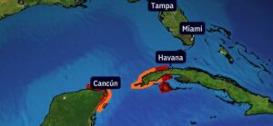
Tropical Storm Helene is projected to develop in the western Caribbean Sea and could intensify into a hurricane, posing a threat to Florida and the northern Gulf Coast later this week. Here’s what you need to know:
Key Points to Monitor
- Area of Impact: From Louisiana to Florida, coastal residents should closely monitor updates and be ready with their hurricane plans.
- Current Alerts: A hurricane watch and tropical storm warning are in effect for parts of Mexico’s Yucatan Peninsula, including Cancun, Tulum, and Cozumel, as well as parts of western Cuba.
- Expected Conditions: These regions could experience tropical storm conditions within 36-48 hours, with hurricane conditions also possible.
Current Situation
- Location: A broad area of low pressure is currently in the western Caribbean Sea, with thunderstorms becoming increasingly organized.
- Potential Development: This system is labeled as Potential Tropical Cyclone Nine by the National Hurricane Center (NHC), allowing for early issuance of warnings and alerts before the storm officially forms.
Forecast Timeline
Monday-Tuesday:
- A tropical depression or storm could develop as early as late Monday or Tuesday.
- By late Tuesday, Helene might approach Cancun, Cozumel, and western Cuba as a tropical storm or possibly a Category 1 hurricane.
- Potential Impacts: Locally heavy rain, strong winds, and storm surge flooding. Western Cuba could see over 12 inches of rain.
Wednesday:
- Helene may continue to affect Cancun, Cozumel, and western Cuba, particularly early in the day.
- The storm is expected to enter the southern Gulf of Mexico as a hurricane, with high surf and outer rainbands reaching Florida’s Gulf Coast from the Keys to the Panhandle.
Thursday:
- Helene is forecasted to make landfall as a strong hurricane on Thursday afternoon or evening. The exact landfall location remains uncertain, but current models suggest it could hit anywhere from Florida’s Big Bend to the Panhandle.
- Uncertainty in Track: Forecasts also show potential tracks as far east as Florida’s West Coast and as far west as southeast Louisiana or Mississippi.
Recommendations
- Stay-updated…
- Prepare for possible impacts like storm surge, heavy rain, and strong winds, even if you’re outside the direct path of the storm.
Sources
Stay safe and be prepared for any changes in the storm’s path and intensity!


